NNA: Remote Sensing of Arctic Sea Ice Using the Super Dual Auroral Radar Network
Long-running observations of sea ice extent and characteristics are crucial to understanding environmental changes in the Arctic. The Super Dual Auroral Radar Network (SuperDARN) is an international network of ground-based, high-frequency (HF) space weather radars which have operated continuously in the Arctic and Antarctic regions for more than 30 years. The objectives of this project are to analyze historical and ongoing SuperDARN ground backscatter measurements for extraction of Arctic sea ice parameters. Comparisons will be made to sea ice measurements obtained from space-based microwave remote sensors. An operational sea ice data product derived from SuperDARN HF radar observations will be submitted to the Arctic Data Center for long-term preservation and accessibility by the broader Arctic research community.
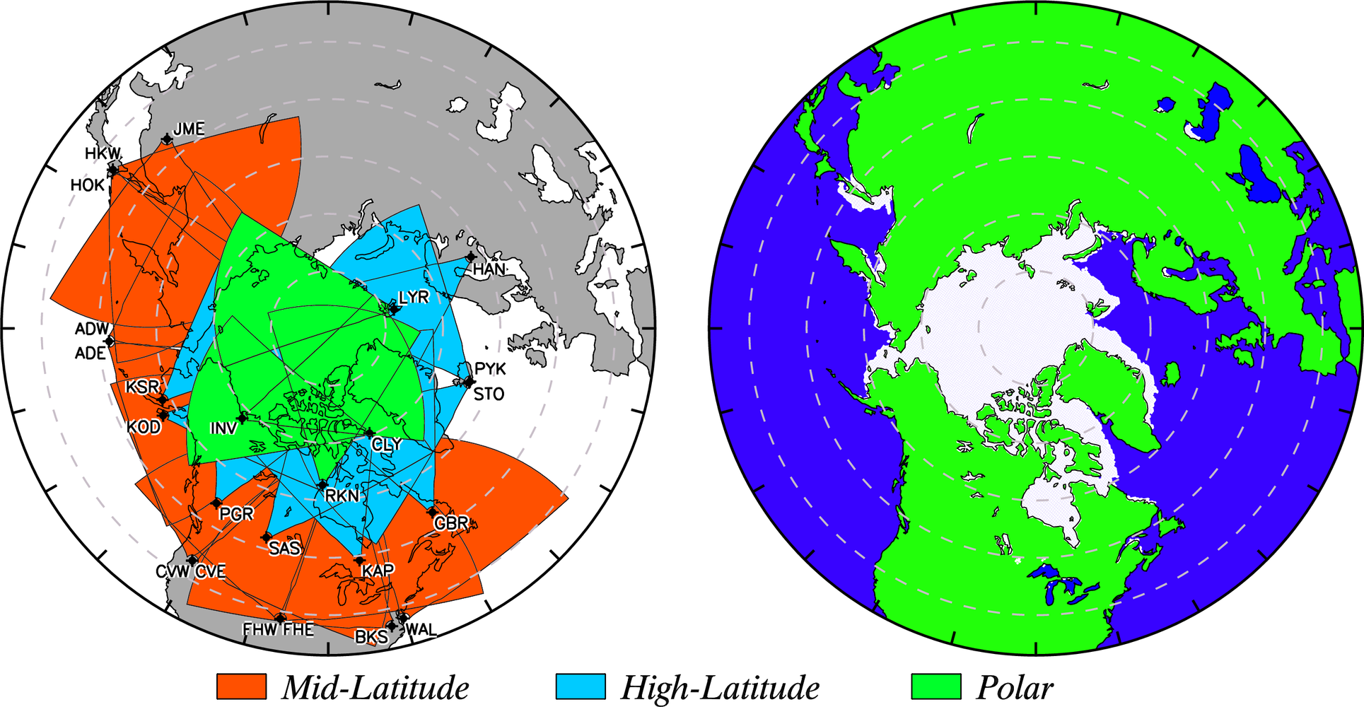
Figure: (left) Fields of view of the Northern Hemisphere SuperDARN radars in geographic coordinates. Mid-latitude, high-latitude, and polar radar fields of view are shaded orange, blue, and green respectively. (right) Interactive Multisensor Snow and Ice Mapping System Daily Northern Hemisphere 24 km sea ice extent on 01 January 2021.
Publications
- Thomas, E. G., S. G. Shepherd, and G. Chisham (2024), Multi-frequency SuperDARN interferometer calibration, Radio Sci., 59, doi:10.1029/2024RS007957.
- Thomas, E. G., and S. G. Shepherd (2022), Virtual height characteristics of ionospheric and ground scatter observed by mid-latitude SuperDARN HF radars, Radio Sci., 57, doi:10.1029/2022RS007429.
- Chisham, G., A. G. Burrell, A. Marchaudon, S. G. Shepherd, E. G. Thomas, and P. V. Ponomarenko (2021), Comparison of interferometer calibration techniques for improved SuperDARN elevation angles, Polar Sci., 28, 100638, doi:10.1016/j.polar.2021.100638.
Conference Presentations
- Remote Sensing of
Arctic Sea Ice Using the Super Dual Auroral Radar Network: New Results and Data Products,
AGU Fall Meeting, C11C-04, Chicago, IL, 12 December 2022.
- Sustained
Observations of Arctic Sea Ice Using the Super Dual Auroral Radar Network: First Results,
AGU Fall Meeting, C25G-0887, New Orleans, LA, 14 December 2021.
-
Empirical virtual height characteristics of ionospheric and ground scatter observed by the
mid-latitude Christmas Valley SuperDARN HF radars,
34th URSI General Assembly and Scientific Symposium, Rome, Italy, 31 August 2021.
- Improved
classification and geolocation of SuperDARN ground scatter,
AGU Fall Meeting, SA51C-3169, San Francisco, CA, 13 December 2019.
- Remote
Sensing of Arctic Sea Ice Using the Super Dual Auroral Radar Network,
AGU Fall Meeting, C32C-02, Washington, DC, 12 December 2018.
Resources
This material is based upon work supported by the National Science Foundation under Grant Number OPP-1836426. Any opinions, findings, and conclusions or recommendations expressed in this material are those of the author(s) and do not necessarily reflect the views of the National Science Foundation.